- Project Leader : Hasegawa Hiroyuki (Japan Federation of Land and House Investigators’ Associations)
- Collaborators : Shibayama Mamoru (Kyoto University, ASEAN Center)
- : Kobayashi Satoru (Kyoto University, Center for Southeast Asia Studies)
- : Elizabeth Howard Moore (University of London, School of Oriental and African Studies)
- : Miyahara Kengo (Kyoto Archaeological Institute)
Outline of Research
This project aims to develop a new method of studying landscape changes in mainland Southeast Asia by constructing a 3D-Image Map Archive of William-Hunt Collection (hereafter, WHC). WHC is the sole aerial photo collection in the 1940s~1950s, which covers various areas in mainland Southeast Asia. Based on the achivement of the last year in whick we examined the original photo collections of WHC both at the School of Oriental and African Studies (SOAS), Univeristy of London and at the map room of CSEAS, the project will develop 3D Image Map Archive Configuration Database, which focuses on Myanmar for exploring landscape change of the country as s case area.
Purpose
The project has three purposes. The first is to determine the complete list of the photos of WHC and finalize their digitalization. The second is to develop a 3D Image Map Archive as a technique for identifiny and querying landscape changes by using aerial photos and photogrammetry. The third purpose is to study social changes of mainland Southeast Asia after mid 20th century, using WHC aerial photos.
One of the three goals of this project; to identify the complete list of photos of WHC and finalize their digitalization, was accomplished last year. The project will try to achieve the remaining two goals in this year; that is, to develop a 3D Image Map Archive as a technique for identifiny and querying landscape changes by using aerial photos and photogrammetry and to study social changes by using them.
Significance
The pursuit of three goals mentioned above has a groundbreaking role to develop a new method of historical area studies as well as Area Informatics. At the same time, this project will contribute to the Southeast Asian research community studying Southeast Asia before World War II by establishing a database of WHC at CSEAS and SOAS.
The project will contribute to area studies by cultivating hidden potential of maps and aerial photos for studying historical transformations of Southeast Asia region. The new technology of constructing 3D image Maps shed a new light on those historical materials. At the same time, the project will explore the diverse forms of utilizing WHC, one of the best materials for researching archeology, economic geography, history and geo-informatics in mainland Southeast Asia.
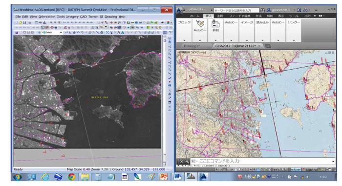 ALOS-1 satellite stereo images and DGPS-GCPs with 1 second interval positioning |
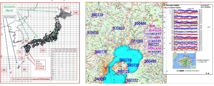 2011-2015—national network adjustment and Sakurajima project (volcanic eruption) |